Dosya:Arab population israel 2000 en.png
Bu önizlemenin boyutu: 263 × 599 piksel. Diğer çözünürlükler: 105 × 240 piksel | 211 × 480 piksel | 692 × 1.575 piksel.
Tam çözünürlük ((692 × 1.575 piksel, dosya boyutu: 182 KB, MIME tipi: image/png))
Bu dosya Wikimedia Commons'ta bulunmaktadır. Dosyanın açıklaması aşağıda gösterilmiştir. Commons, serbest/özgür telifli medya dosyalarının bulundurulduğu depodur. Siz de yardım edebilirsiniz. |
Özet
| Açıklama |
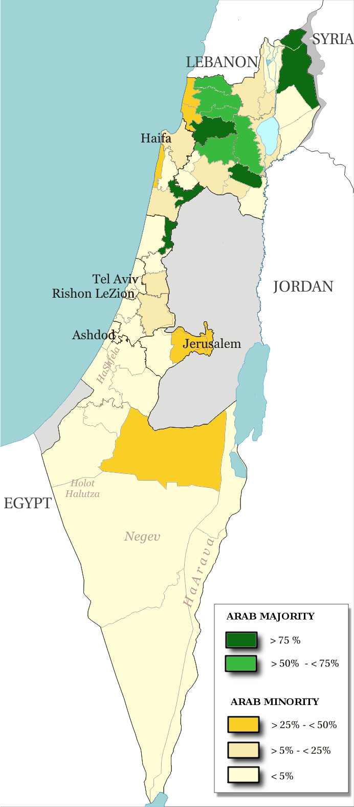
English: Map of the officials 50 "natural regions" of Israel, with their proportions of arab population. The map includ the Golan heights and east Jerusalem, two areas annexed by Israel, annexions not recognize by UNO.
The map is based on the demographic situation 2000, and is based upon the arab population in Israel [PDF], a publication (Statistilite N°27) of the israeli Center Bureau of Statistics (CBS) diffused in november 2002.
Français : Carte des 50 "régions naturelles" officiellement reconnues par l'état, subdivision des 15 sous-districts, avec la proportion de population arabe. Cette carte inclue Jérusalem-Est et le plateau du Golan, tous deux annexés par Israël, mais dont l'annexion n'est pas reconnue par l'ONU.
La carte est basée sur la situation de la population en l'an 2000, et est inspirée de the arab population in Israel [PDF], une publication (Statistilite N°27) du Center Bureau of Statistics israélien (CBS) diffusée en novembre 2002. |
| Tarih | |
| Kaynak | Own work, derivative work of: File:Israel population density.png |
| Yazar | Christophe cagé |
| Diğer sürümler | File:Arabe population israel 2000 fr.png |
Lisanslama

|
Bu dosyanın telif hakkı sahibi, Israel Central Bureau of Statistics, telif hakkına uygun şekilde atıfta bulunmak koşuluyla herkese herhangi bir amaç için bu çalışmayı kullanmak üzere izin vermiştir. |
Atıf:
The Central Bureau of Statistics (CBS), {{{filename}}}, ({{{access-date}}}), [{{{link}}} available online] copied and distributed as is in accordance with the CBS license.
|

|
According to the CBS license, you may not make the following use of the Information, whether by positive act or by omission:
|
Ben, bu işin telif sahibi, burada işi aşağıdaki lisanslar altında yayımlıyorum:

|
Bu belgenin GNU Özgür Belgeleme Lisansı, Sürüm 1.2 veya Özgür Yazılım Vakfı tarafından yayımlanan sonraki herhangi bir sürüm şartları altında bu belgenin kopyalanması, dağıtılması ve/veya değiştirilmesi için izin verilmiştir;
Değişmeyen Bölümler, Ön Kapak Metinleri ve Arka Kapak Metinleri yoktur. Lisansın bir kopyası GNU Özgür Belgeleme Lisansı sayfasında yer almaktadır. |
Bu dosya Creative Commons Atıf-Benzer Paylaşım 3.0 Aktarılmamış, 2.5 Genel, 2.0 Genel ve 1.0 Genel lisansları ile lisanslanmıştır.
- Şu seçeneklerde özgürsünüz:
- paylaşım – eser paylaşımı, dağıtımı ve iletimi
- içeriği değiştirip uyarlama – eser adaptasyonu
- Aşağıdaki koşullar geçerli olacaktır:
- atıf – Esere yazar veya lisans sahibi tarafından belirtilen (ancak sizi ya da eseri kullanımınızı desteklediklerini ileri sürmeyecek bir) şekilde atıfta bulunmalısınız.
- benzer paylaşım – Maddeyi yeniden karıştırır, dönüştürür veya inşa ederseniz, katkılarınızı orijinal olarak aynı veya uyumlu lisans altında dağıtmanız gerekir.
İstediğiniz lisansı seçebilirsiniz.
Dosya geçmişi
Dosyanın herhangi bir zamandaki hâli için ilgili tarih/saat kısmına tıklayın.
| Tarih/Saat | Küçük resim | Boyutlar | Kullanıcı | Yorum | |
|---|---|---|---|---|---|
| güncel | 13.48, 15 Temmuz 2014 | | 692 × 1.575 (182 KB) | Hruska~commonswiki | Reverted to version as of 08:23, 22 February 2009 |
| 13.47, 15 Temmuz 2014 |  | 692 × 1.575 (182 KB) | Hruska~commonswiki | Reverted to version as of 08:23, 22 February 2009 Revert Edit, The Golan and East Jerusalem de facto Israel, Syria giving Status qo | |
| 13.46, 15 Temmuz 2014 |  | 692 × 1.575 (182 KB) | Hruska~commonswiki | Reverted to version as of 08:23, 22 February 2009 | |
| 15.38, 21 Nisan 2009 |  | 692 × 1.575 (165 KB) | MeteorMaker~commonswiki | {{Information |Description={{en|1=Map of the officials 50 "natural regions" of Israel, with their proportions of arab population. The map includ the Golan heights and east Jerusalem, two areas annexed by Israel, annexions not recognize by UNO. The map is | |
| 08.23, 22 Şubat 2009 |  | 692 × 1.575 (182 KB) | Christophe cagé | {{Information |Description={{en|1=x}} {{fr|1=x}} |Source=travail personnel (own work) |Author=Christophe cagé |Date=22 february 2009 |Permission=SEE LICENSE |other_versions= }} <!--{{ImageUpload|full}}--> |
Dosya kullanımı
Bu görüntü dosyasına bağlantısı olan sayfalar:
Küresel dosya kullanımı
Aşağıdaki diğer vikiler bu dosyayı kullanır:
- azb.wiki.x.io üzerinde kullanımı
- bg.wiki.x.io üzerinde kullanımı
- bn.wiki.x.io üzerinde kullanımı
- ca.wiki.x.io üzerinde kullanımı
- ckb.wiki.x.io üzerinde kullanımı
- cs.wiki.x.io üzerinde kullanımı
- da.wiki.x.io üzerinde kullanımı
- de.wiki.x.io üzerinde kullanımı
- el.wiki.x.io üzerinde kullanımı
- en.wiki.x.io üzerinde kullanımı
- eo.wiki.x.io üzerinde kullanımı
- es.wiki.x.io üzerinde kullanımı
- fa.wiki.x.io üzerinde kullanımı
- fi.wiki.x.io üzerinde kullanımı
- gl.wiki.x.io üzerinde kullanımı
- he.wiki.x.io üzerinde kullanımı
- ja.wiki.x.io üzerinde kullanımı
- ku.wiki.x.io üzerinde kullanımı
- mn.wiki.x.io üzerinde kullanımı
- pt.wiki.x.io üzerinde kullanımı
- ro.wiki.x.io üzerinde kullanımı
- ru.wiki.x.io üzerinde kullanımı
- simple.wiki.x.io üzerinde kullanımı
- stq.wiki.x.io üzerinde kullanımı
- ta.wiki.x.io üzerinde kullanımı
- uk.wiki.x.io üzerinde kullanımı
- xmf.wiki.x.io üzerinde kullanımı
- zh.wiki.x.io üzerinde kullanımı