Şablon:Petrol sızıntısı bilgi kutusu
| Konum | {{{konum}}} |
|---|---|
| Tarih | {{{sızıntı_tarihi}}} |
| Sebep | |
| Sebep | {{{sebep}}} |
| Kayıplar | {{{kayıplar}}} |
| İşletmeci | {{{işletmeci}}} |
| Sızıntı özellikleri | |
| Miktar | {{{miktar}}} |
| Bölge | {{{bölge}}} |
| Etkilenen sahil şeridi | {{{sahil}}} |
</includeonly>
| Bu şablon şu Lua modüllerini kullanıyor: |
| Bu şablon şu Lua modüllerini kullanıyor: |
Kullanımı
değiştir{{Petrol sızıntısı bilgi kutusu
| ad =
| görüntü =
| görüntü_boyutu =
| görüntü_altyazı =
| görüntü_görünmez_yazı =
| harita_ülke =
| harita_altyazı =
| harita_görüntüsü =
| harita_boyutu =
| latd =
| latm =
| lats =
| latNS =
| longd =
| longm =
| longs =
| longEW =
| map_dot_label =
| relief =
| konum =
| iso_region =
| coordinates_display =
| coordinates_format =
| koordinatlar =
| sızıntı_tarihi =
| sebep =
| işletmeci =
| kayıplar =
| miktar =
| bölge =
| sahil =
}}
Required: name, location, spill_date, and at least one of volume/area/coast.
Unused parameters do not need to be stated (i.e. it isn't necessary to put "casualties = none" or "coast = n/a").
| Exxon Valdez petrol sızıntısı | |
|---|---|
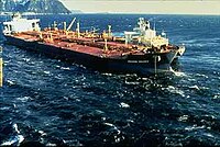
 Exxon Valdez'in karaya vurmasından 3 gün sonra | |
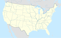
| Konum | Prince William Sound, Alaska |
| Koordinatlar | 60°50′26.88″K 146°51′45″B / 60.8408000°K 146.86250°B |
| Tarih | 24 Mart 1989 |
| Sebep | |
| Sebep | Exxon Valdez petrol tankerinin karaya vurması |
| İşletmeci | ExxonMobil |
| Sızıntı özellikleri | |
| Miktar | 41.000 metreküp (260.000 bbl) - 119.000 metreküp (750.000 bbl) |
| Bölge | 28.000 km2 (11.000 sq mi) |
| Etkilenen sahil şeridi | 2.100 km (1.300 mi) |
| Parameter | Description | Example |
|---|---|---|
| name | should match article name, wiki markup OK | ''Exxon Valdez'' oil spill |
| image | do not include "File:" | Exval.jpeg |
| image_size | value in pixels, uses default image size if not set. | 250px |
| image_caption | description appears centered below image | 3 days after ''[[Exxon Valdez]]'' ran aground |
| location | general description of site, preferably with wikilinks | [[Prince William Sound]], [[Alaska]] |
| coordinates | specific location using Coord template (can also be used to cause coordinates to appear in article title by setting "display=title,inline") | {{Coord|60.83333|-146.86667|region:US-AK_type:landmark|display=inline}} |
| location_map_zoom | Zoom level for the location map (0-19) | 7 |
| spill_date | start of spill event (or range of dates, for extended spills) | 24 March 1989 |
| cause | general description of event that initiated the spill | Grounding of the ''[[Exxon Valdez]]'' oil tanker |
| operator | company that is financially responsible for spill event (if applicable) | [[Exxon]] |
| casualties | deaths or injuries associated with initial spill event (if applicable) | |
| volume | amount of oil spilled (or range of best estimates) Note: some spills are listed as mass (tonnes) instead of volume. See list of oil spills for typical conversions. |
{{convert|260000|oilbbl|m3}} - {{convert|750000|oilbbl|m3}} |
| area | area affected by oil (i.e. seafloor or land) | {{convert|11000|mi2|abbr=on}} |
| coast | linear length of coastline affected | {{convert|1300|mi|abbr=on}} |
